
Geography: Grade 9 12 Sections48 Lessons365 Days
1.4. Land Forms of Ethiopia
The Landforms of Ethiopia
Geography Grade 9
Lesson Competencies
At the end of the lesson you will be able to:
Explain the difference between endogenic and exogenic forces in shaping landforms.
Identify the major physiographic divisions of Ethiopia.
Describe the key characteristics and major peaks of the Ethiopian highlands.
Recognize the main features of the Ethiopian Rift Valley and its sections.
Key Terms
Endogenic Forces
Forces that originate from within the Earth, such as volcanic eruptions and earthquakes, that create and build up landforms.
Exogenic Forces
Forces that originate on the Earth’s surface, such as erosion by water and wind, that wear down and modify landforms.
Physiography
The study of the Earth’s physical features and landforms.
Rift Valley
A large elongated valley with steep walls formed by the sinking of a block of land between two faults or fractures in the Earth’s crust.
Video Lesson
Core Lesson: The Diverse Landscapes of Ethiopia
Dear learners,
Ethiopia is a country of dramatic contrasts, from the soaring peaks of the Simien Mountains to the scorching, low-lying Danakil Depression. These incredible landscapes were not formed overnight. They are the result of millions of years of powerful natural processes working both from inside the Earth and on its surface.
Today, we will journey through Ethiopia’s amazing scenery, exploring the powerful forces that created it and the major regions that define our country’s unique geography.
The Forces That Shape the Land
Endogenic Forces (Building Up)
These are internal forces. Think of them as Earth’s construction crew. Volcanism, faulting, and earthquakes push up mountains, create plateaus, and split the land to form great valleys. The Ethiopian Highlands and the Great Rift Valley are prime examples of their work.
Exogenic Forces (Wearing Down)
These are external forces. Think of them as nature’s sculptors. Rain, rivers, wind, and ice slowly erode (wear away) the land built by endogenic forces, carving deep gorges, creating gentle slopes, and depositing rich soil.
The Three Major Physiographic Divisions
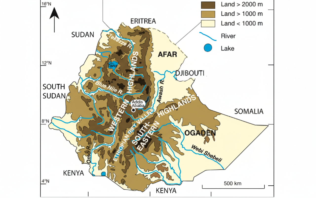
The Great Rift Valley acts like a giant divider, splitting Ethiopia’s highlands into two main parts and creating three distinct physiographic regions. Let’s explore each in detail.
1. The Western Highlands and Lowlands
This is the largest and most rugged physiographic region of Ethiopia, containing its highest peaks and the sources of its major rivers.
| Subdivision | Location / Boundaries | Key Features | Notable Peaks / Areas |
|---|---|---|---|
| Plateau of Tigray | Northernmost plateau. Bounded by Mereb River (N) and Tekezze River (S). | Drained by Mereb & Tekezze tributaries; sandstones and limestones; poor, thin soils; severe erosion. | Mount Tsibet (3988m), Mount Ambalage (3291m), Mount Assimba (3248m). |
| North Central Massif | Between Abbay Gorge (S) and Tekezze Gorge (N); includes highlands of Gondar, Gojjam, Wollo. | Most rugged and dissected plateaus; deep gorges and steep valleys; basalt-capped ambas; important cereal production. | Ras Dashen (4550m), Guna (4231m), Abuna Yoseph (4190m). |
| Plateau of Shewa | Smallest subdivision; watershed between Awash, Omo-Gibe, and Abbay basins. | Dome-shaped; separated by Abbay Gorge (N), Awash River (SE), and Gibe River (SW). | Mount Abbuye Meda (4000m), Mount Guraghe (3721m). |
| Southwestern Highlands | South of Abbay Trough; includes Wollega, Illubabor, Jimma, Kafa, Gamo, Goffa. | Wettest region (>1500mm rain); highly eroded; rich forest cover; vital for coffee, spices, timber. | Mount Gughe (4200m), Tullu Wallel. |
Western Lowlands
- Location: Stretch from Western Tigray to Southern Gamo, bordering Sudan and South Sudan (500-1000m elevation).
- Climate: Mostly arid and semi-arid, with a pastoral lifestyle common. The Baro-Akobo area is the wettest part.
- Subdivisions: Tekezze and Angereb Lowlands, Abbay-Dinder Lowlands, Baro-Akobo Lowlands, Omo-Gibe Lowlands.
2. The Southeastern Highlands and Lowlands
This is the smaller of the two highland plateaus, separated from the Western Highlands by the Rift Valley.
| Subdivision | Location / Boundaries | Key Features | Notable Peaks / Areas |
|---|---|---|---|
| Hararghe Plateaus | Rises from Rift Valley fault line, extends east to Jigjiga. | Drained by Wabe Shebelle tributaries; exposed limestones; major crops: coffee, chat, sorghum. | Mount Gara Muletta (3381m). |
| Arsi Plateau | Includes Gugu and Chillalo Massif. | Rolling plateau suitable for farming; known for wheat production; low relief due to erosion. | Mount Kaka (4180m), Mount Bada (4139m). |
| Bale Massif | South of Arsi Plateau, separated by Wabe Shebelle headstreams. | Northern part is a flat basaltic plateau; southern part has massive mountains; known for barley production. | Tullu Dimtu (4377m), Mount Batu (4307m). |
| Sidama Highlands | Southwest extension, separated from Bale by Genale River Valley. | Slopes south and southeast; drained by Genale River and its tributaries. | Forms an important highland region. |
Southeastern Lowlands
- Location: Extend from the foothills of the highlands along the Ethio-Somalian and Ethio-Kenyan borders.
- Features: Extensive lowlands (Ogaden, Elkeri, Borena plains); extreme climate with low rainfall (<500mm/year); pastoralist lifestyle is dominant.
3. The Rift Valley
This massive tectonic trench cuts through Ethiopia, creating a distinct region of lowlands, lakes, and volcanoes.
| Subdivision | Location / Extent | Key Features | Special Characteristics / Examples |
|---|---|---|---|
| The Afar Triangle | Largest and widest part (200-300km wide); elevation from -116m to 900m. | Low elevation (much below sea level); faulted depressions, volcanic mountains, extensive salt plains. | Lake Assale, Lake Afrera, Dallol Depression, Erta Ale Volcano, rich archaeological sites. |
| The Main Ethiopian Rift | From lower Awash basin to Lake Chamo; narrowest and most elevated part. | Wettest and most densely vegetated; densely populated; sedentary farming is practiced. | Chain of lakes (Ziway, Langano, Shalla, Abijatta); important for agriculture and settlements. |
| The Chew-Bahir Rift | Smallest section, south of Lakes Region, separated by Konso Highlands. | Extensive, shallow marshy area with tall grasses; streams like Sagan and Woito drain here. | Predominantly pastoralist population; known for seasonal wetlands and grazing lands. |
Activity 1: Check Your Knowledge
Activity 2: Fact or Fiction?
Activity 3: Match the Feature
Lesson Summary
Ethiopia’s landforms are shaped by two main types of forces: Endogenic forces (like volcanism) that build up the land, and Exogenic forces (like erosion) that wear it down.
The country is divided into three major regions by the Great Rift Valley: the large Western Highlands (home to Ras Dashen), the smaller Southeastern Highlands (home to the Bale Mountains), and the Rift Valley itself.
The Rift Valley has three distinct sections: the hot and low Afar Triangle, the lake-filled Main Ethiopian Rift, and the southern Chew Bahir Rift.
Final Assessment
Competency Checklist
Check off the skills you’ve mastered in this lesson.